SE 78th Avenue is closed to through traffic due to fallen tree limbs between SE Stark and Washington Streets. The large tree branches, which accounted for nearly 50% of the tree’s mass, fell across the roadway on June 30th, blocking traffic and lying across two vehicles. No significant damage or injury occurred. A Portland Parks & Recreation Urban Forestry representative has arrived at the site.
Photo by Michael Kora
Drivers who use SE 78th Avenue to change direction on the SE Stark-Washington couplet will need to use SE 76th Avenue or SE 80th Avenue. Crews will likely require several hours to clear the street for cars. Pedestrians can pass the tree on the sidewalk, but should detour around the area to avoid the workers cleaning up leaves and branches lying on SE 78th Avenue. Arborists will need to determine if the remaining tree structure is safe to leave standing.
SE 78th Ave east sidewalk partially blocked. Photo by Crossett FreilingerSE 78th Ave west sidewalk partially blocked with Urban Forestry vehicle. Photo by Crossett Freilinger
Promotion: Montavilla News is supported by contributions from businesses like Otter Wax, a neighborhood producer of small-batch specialty goods handcrafted in Portland. Using only natural ingredients, they make modern care products that are steeped in tradition. We thank them for their support.
In the latter half of June, road crews reopened NE Halsey Street to bidirectional automotive traffic after months of work creating a new mini-roundabout near Interstate 84 and NE 82nd Avenue. Additionally, drivers regained full use of NE 80th and NE 81st avenues at the worksite intersections. Starting on February 16th, westbound motorists on NE Halsey Street were prevented from fully crossing the I-84 overpass as cement masons created the second half of a new mini-roundabout and other contractors built additional street improvements.
NE Halsey mini-roundabout approach from NE 81st Avenue.
As this work nears completion, the Portland Bureau of Transportation (PBOT) recently scaled back plans for the NE Halsey Street Safety and Access to Transit Project, postponing a planned intersection improvement at NE 69th Avenue and removing a 150-foot section of new sidewalk and street trees from the project’s scope. PBOT says the $380,000 in cost savings is necessary to meet reduced funding for this project while still maintaining core improvement goals of filling gaps in walking and biking connections on NE Halsey Street from NE 80th to NE 92nd avenues.
Rendering of NE Halsey roundabout post 2026 update to remove sidewalk section, courtesy PBOT
The newly renamed NE Halsey Street (80th to 92nd Avenues) – Safety and Access to Transit Project contains many safety improvements for people walking and biking through the area. Future work will create a dedicated bidirectional cycle path from the mini-roundabout to 92nd Avenue through a challenging section of the City’s street grid carved up by freeway construction decades ago. Work on this project could help reconnect communities cut off by car-focused street infrastructure, while reducing injuries on an identified High Crash street.
Drivers and other street users should use caution around this new infrastructure, as the adjusted traffic pattern could confuse people unfamiliar with the change. The raised concrete center circle is designed with sloped edges so that long vehicles, such as first-responder trucks or buses, can drive over it, treating it as a speed bump when necessary. Look for continued road work east of the mini-roundabout as contractor Interlaken and its subcontractors work along the length of the NE Halsey job site.
Promotion: Montavilla News is supported by contributions from businesses like Catalyst Construction & Kitchen Remodeling, a top-rated general contractor specializing in kitchen, bathroom, basement, and garage remodeling, as well as ADU construction and home additions. We thank them for their support.
Portland Parks & Recreation (PP&R) launched a pilot express shuttle service this summer to help people from all over the city reach Forest Park and Washington Park. Shuttle buses operate on a regular Friday and Saturday schedule with stops extending into neighborhoods within East, North, and Northeast Portland. Park officials hope this program will allow more people to connect with the vast park resources on the west side of the City.
Washington Park reflecting pool 3
The Forest Park and Washington Park Express Shuttle began service on June 12th and will operate until the end of the pilot program on August 22nd. Regional private transportation provider EcoShuttle is operating buses for the program, making regular stops between select neighborhoods and the two popular city parks. The free buses provide access to the unique park resources of Forest Park and Washington Park, as well as planned activities. Shuttle schedules to the parks and back to boarding points vary, and interested riders should consult the program’s website before making plans. Additionally, pets are not allowed on the shuttle, but service animals are allowed to accompany their people.
Forest & Washington Park Express Shuttle Map Courtesy PP&R
Montavilla and East Portland residents can access the shuttle at the Gateway Transit Center on NE 99th Avenue or the entrance to Floyd Light Middle School at 826 SE 108th Avenue. Riders can find a timetable on a sign near the stop by looking for the Express Shuttle logo. Restrooms and other facilities at the adjacent community center are available to people waiting for the shuttle during center operating hours. The park terminus is located at the traffic circle at the Lower Macleay Trailhead, which features picnic tables, a covered picnic pavilion, Americans with Disabilities Act (ADA)-accessible restrooms, and a short, paved, ADA-accessible trail.
Forest & Washington Park Express Shuttle schedule Courtesy PP&R
Within the parks, a connecting shuttle takes riders to Washington Park, Oregon Zoo (Stop A), Pittock Mansion (Stop B), Upper Macleay Trailhead (Stop C), Lower Macleay Trailhead (Stop D), and Leif Erikson Drive Trailhead at Germantown Road (Stop E). PP&R collaborated with community partners who offer programming that includes guided hikes, events, and activities in Forest and Washington Parks.
TriMet transit options remain a good way to access Forest Park and Washington Park. However, this express shuttle eliminates travel costs and speeds up the journey across the city. Organizers hope this program will help people enjoy Portland’s largest parks during these warm summer days, when people are looking to get outdoors. Interested residents have until August 22nd to take advantage of this free express shuttle service.
Promotion: Check out East Portland News as it continues to advocate for and report on outer East Portland. You will find frequently updated articles and an archive of more than 5,000 stories written over the past 20+ years alongside a robust Community Calendar of events.
Drivers on SE Thorburn Street merging into SE Washington Street up to I-205 will see a new 25 miles per hour (mph) speed limit. The Portland Bureau of Transportation (PBOT) reduced speeds on the roadway from 30 mph in June as its contractors began work creating approximately 355 feet of new sidewalk on the north side of SE Thorburn Street, between SE 73rd Avenue and SE 74th Avenue, filling a sidewalk gap. This work follows a 2025 lane reconfiguration in the area that reduced the number of travel lanes in each direction and added improved bike and walking infrastructure.
New 25 mph speed limit sign on SE Washington st
PBOT changes speed limits regularly to improve street user safety. The 2025 redesign made space for increased pedestrian access on both sides of the roadway and created dedicated bike lanes. The slightly reduced vehicle speeds will help those outside a motorized vehicle remain safe and lessen the injury caused by a crash. People walking or rolling on the south side of SE Thorburn Street use an on-roadway path, as the sloped topology and mature tree line of the adjacent properties make sidewalk expansion more involved. The north side of the street has some sidewalks that are narrow and curb tight—lacking a buffer space between the pedestrian zone and the raised curb.
SE Thorburn Street sign showing old speed of 30 mph
In a section of SE Thorburn Street where people walk through grassy, undeveloped land and gravel paths near SE 74th Avenue, contractors working for PBOT will build a 7-foot-wide sidewalk, with some sections reduced to 5 feet wide, to preserve existing street trees. During that work, cement masons will create new curb ramps at the intersection of SE 74th Avenue and reshape the sidewalk corners to make the intersection more perpendicular, which can slow turning vehicles and lessen the pedestrian crossing distance.
Project desing imag courtesy PBOT
This work is part of the Jade and Montavilla Multimodal Improvements Project and is funded by general transportation revenue, House Bill 2017, with a budget of $371,000. Crews working in the area will periodically close one lane of vehicle traffic on SE Thorburn Street between SE 73rd and 74th avenues through June 30th. Street users should anticipate some delays and detours as construction continues in the area. Drivers should also note the new, slower speeds on these streets.
Promotion: Montavilla News is supported by contributions from businesses like Catalyst Construction & Kitchen Remodeling, a top-rated general contractor specializing in kitchen, bathroom, basement, and garage remodeling, as well as ADU construction and home additions. We thank them for their support.
TriMet will observe this year’s Transit Driver Appreciation Day on March 18th. For over a decade, the municipal transportation corporation has used this day to invite its users to thank those who keep the system moving. If riding on public transportation this Wednesday, event organizers encourage people to say “thank you,” wave, give a card, or smile at the operator. Riders can sign a banner at one of four transit center locations or post their message of thanks on an online kudoboard.
Image courtesy triMet
TriMet’s role is critical in building housing density and lowering Oregon’s carbon output. Modern Portland multi-family developments often lack onsite parking or offer minimal vehicle storage space. This development model helps maximize the housing units on a property and encourages people to forgo a private vehicle. Instead, city planners who rezone for more density anticipate that residents will use other commuting methods, including public transit. This model should reduce the environmental impact of transportation in Oregon, but it depends on fast and effective alternatives that use less polluting propulsion. TriMet is the largest transportation provider in the region for those without personal vehicles, providing over 56 million rides in the 2025 fiscal year.
Transit drivers are not only responsible for safely moving people throughout the community but also play an impactful role in reducing climate change and mitigating the housing crisis. TriMet drivers always welcome daily appreciation, but March 18th is an appropriate time to communicate your gratitude.
At the beginning of the year, TriMet announced a series of proposed cost-cutting measures planned for August and asked for rider feedback via an online survey. Those early cost-saving adjustments would have eliminated the Line 19 Bus route, among other reductions, and its closure would have ended NE Glisan Street’s century-long run as Montavilla’s transit backbone. The transit provider updates its proposal with a partially restored Line 19 route that will retain most of the existing path from the Gateway Transit Center to Downtown Portland. The TriMet Board of Directors will consider the updated proposals and vote on these changes on April 22nd.
Other potential changes were also refined to lessen reported impact but would similarly reduce functionality for transit users, push more people to existing TriMet lines, or encourage driving to some destinations. TriMet leaders are trying to close a $300 million annual budget gap through a variety of measures. Since first announcing the issue in July 2025, the transit agency says it has reduced spending by about $150 million through cutting expenses, eliminating staff positions, and pausing service expansion efforts. The next round of reductions aims to trim service or remove low-ridership lines where riders have other, sometimes less functional, options. In fiscal year 2025 (July 1st, 2024, through June 30th, 2025), 15,600 riders boarded Line 19 each week. Of those weekly transit users, 7,617 started their trip between I-205 and stops at Southwest Lincoln Street and 4th Avenue in Downtown Portland. Losing that route alarmed some riders, who were vocal in their opposition to the change.
TriMet graphic from March 2026 showing current and proposed cuts to the MAX Green Line and Line 19 bus route among others
The updated plans for the NE Glisan Street bus would maintain Line 19 along the busy commercial street where it serves several high-traffic destinations, including Providence Portland Medical Center. Downtown, the updated route would connect with the Line 58 path, creating a direct transit link between the Beaverton and Gateway transit centers. The line’s name would change to “19-Glisan/Canyon Rd” to reflect the updated path west of Downtown Portland. Lines 4 and 10 buses would cover some of the southeast leg of the route currently served by Line 19.
TriMet graphic from January 2026 showing current and proposed cuts to the MAX Green Line and Line 19 bus route among others
Promotion: Check out East Portland News as it continues to advocate for and report on outer East Portland. You will find frequently updated articles and an archive of more than 5,000 stories written over the past 20+ years alongside a robust Community Calendar of events.
On Wednesday night, February 25th, community members and City representatives gathered in the cafeteria at Atkinson Elementary School for District 3’s local transportation funding open house. This is one in a series of four in-person events led by the Portland Bureau of Transportation (PBOT) to help inform the Portland City Council, which will consider new ways to fund the maintenance and operation of Portland’s streets. Mayor Keith Wilson spoke at the event, summarizing some of the alternative funding options under consideration. People interested in learning more and contributing their perspective can visit the online open houseand take a post-open house survey.
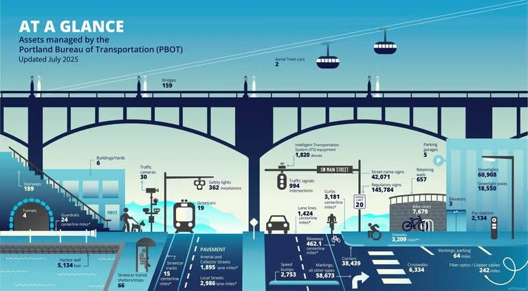
The two-hour event at 5800 SE Division Street saw visitors drop in between 6:30 and 8:30 p.m. as they moved through a self-guided arrangement of poster boards, with City staff available to ask questions and take notes. Portland transportation leaders have spent years warning the community and elected officials that its funding is overburdened by project-based restrictions, preventing 70% of PBOT’s budget from reducing a $6 billion maintenance backlog that impacts road conditions, sidewalks, bridges, signs, lights, and other infrastructure. Much of the funding sourced from Federal and Oregon State sources is for specific projects, such as new crossings or other safety infrastructure, and cannot directly fill potholes or repave roads. Even if a one-time grant were sourced to repair all of Portland’s transportation infrastructure to a “fair” condition, without an updated maintenance revenue source, PBOT assets would decline over the following decades, and a new generation of Portlanders would face the same systemic problem with infrastructure upkeep. In Wilson’s remarks, he painted a troubling picture of Portland’s $85 billion in street assets. “65% of our roads are in a state of not good repair. Most of the nation is above 50%, we are at 35% [for fair condition roads]. So we’re in trouble.”
Mayor Keith Wilson speaking to attendee at the February 25th transportation funding open house
The primary reason for the funding shortfall is inflation, with the presentation material noting that the costs of transportation, construction labor, and materials have increased rapidly while general funding sources have not kept pace. The mayor also pointed to the inequity and ineffective nature of a fixed gas tax that federal legislators have not increased since 1993. “I think we all know that fossil fuels and liquid fuels are going out of style. I drive an electric vehicle myself, and I don’t pay gas taxes. So when we think about paying our fair share, we have to think about the new generation, the new century, and not look to the last century for a failed taxing policy,” said Wilson. He explained the City is looking at “dozens of different options from around the country and the State” to evaluate for Portland transportation funding.
In the open house materials, PBOT has surfaced several proposals that may lay the groundwork for future street funding. Visitors read information about a possible “Street Damage Restoration Fee” that would be charged to utility companies, contractors, or other entities that excavate or trench in the public right-of-way, damaging streets and sidewalks. These crews, including other Portland bureaus, must repair the damage. However, that work often fails to adequately restore the full integrity of a street or sidewalk, and those assets can fail prematurely, a decade or decades earlier than expected.
Presentations also asked attendees to consider a “Transportation Utility Fee” as a funding source, as 31 other Oregon cities have implemented. It could be a monthly fee added to existing public utility bills, which residents and businesses pay. That money collected would support basic road maintenance, such as fixing potholes, and requested safety improvements. A “Retail Delivery Fee” concept would require major retailers to pay a fee for packages delivered to customers through the city’s transportation network. This would come from companies like Amazon, Walmart, Home Depot, Target, and eBay. Colorado and Minnesota have programs like this, but Portland could be the first city to enact this if the City Council adopts this idea. This approach could cover prepared-food transportation in addition to, or in place of, packages with a “Third-Party Food Delivery Fee” similarly proposed.
Asset graphic courtesy PBOT
The open house materials also stressed accountability through audits and transparency. Mayor Wilson’s remarks also centered on shifting taxes rather than simply layering new revenue sources on residents. “The one that we’re gonna be talking about is the transportation utility fee that is going to be a replacement for a gas tax… It’s a real fair way that all houses and/or businesses will pay a portion. My promise to you is if council passes this, I will work to phase out your gas tax for fixing our streets because it’s just not fair, and we have to start rethinking how we’re gonna move our city forward.
PBOT encourages people to visit portland.gov/pbotfunding for more information and share feedback by noon on Wednesday, March 4th, 2026. After that date, extending into May, Portland City Council members will deliberate on the presented materials and community feedback.
Correction: Updated a percentage in Mayor Wilson’s quote clarifying a statement that most cities in the nation have more than 50% of streets in “fair” or “good” condition and Portland is at 35%.
Promotion: Montavilla News is supported by contributions from businesses like Otter Wax, a neighborhood producer of small-batch specialty goods handcrafted in Portland. Using only natural ingredients, they make modern care products that are steeped in tradition. We thank them for their support.
On Friday, February 13th, TriMet leadership instructed the 82nd Avenue Transit Project designers to work toward creating 7 miles of Business Access and Transit (BAT) lanes along most of Portland’s portion of 82nd Avenue. The transformative project would convert the 72 bus line into a Bus Rapid Transit (BRT) system under TriMet’s FX (Frequent Express) moniker, with high-capacity vehicles, modern stations, traffic signal priority, and, now, transit priority on the outer lanes of 82nd Avenue. This updated project scope will increase the current project’s proposed $350 million budget by at least $8 million, and the project partners are depending on yet-unawarded $150 million in federal funding.
TriMet General Manager Sam Desue Jr. made the directive to advance the incorporation of significant BAT lane allocation in the design at the project’s Policy & Budget Committee meeting. This follows months of public dispute over restricting a lane of automotive travel in each direction on a busy north/south connector road that was formerly a state highway until transferring to Portland’s ownership in 2022. BAT lanes serve two primary functions in a transportation network. They are focused on providing local access for vehicles on congested streets and on providing transit systems with a less encumbered lane to move more reliably between stops. Advocates for the design note that driving to a business’s parking lot entrance on a busy road requires a visitor to wait in rush-hour congestion even if they turn onto the street a block away. In those conditions, it can also take a significant time for a motorist leaving a driveway to exit and merge into traffic. BAT lanes can help address those situations by requiring all outer-lane travelers in private vehicles to turn right within a block. Supporters also tout the BAT lanes used by emergency vehicles, which can speed through congestion when time matters.
BAT lanes are strongly supported by surveyed residents who favor a faster, more effective BRT system on 82nd Avenue. People who spoke in support at the 82nd Avenue Transit Project Community Advisory Committee (CAC) meetings also appreciated the anticipated reduced speed of BAT lanes on the curb adjacent portion of the road. 82nd Avenue once had parking along its outer edges that later became travel lanes, leaving pedestrians and fast-moving vehicles inches apart. However, many businesses are concerned about the economic impact of a sudden change in vehicle throughput. Although 82nd Avenue is not at capacity at all times of day, it does often become congested, and transportation models indicate that introducing this level of BAT lanes will divert 20 to 25 percent of traffic to other routes during peak times. Local businesses that started their ventures on a state highway years ago worry that this change will force them to relocate or close as their customers take a different route to avoid heightened congestion. People advocating for 82nd Avenue to transform into a more pedestrian-forward design say that new shoppers will come by foot and by bus, but that mode shift can take years, and many of the small businesses that have made up 82nd Avenue’s culture say they cannot survive the transition timeline, which is far from certain.
Feb 13 Business Access and Transit (BAT) lanes graphic courtesy TriMet with MV News directional notation
The TriMet adopted design for BAT lanes closely represents the community-supported design, and the project 82nd Avenue Transit Project CAC endorsed design, referred to as the “More BAT Lanes” option, with one notable exception. The nearly seven miles of transit-priority updates will stop before and resume after SE Powell Boulevard. During the January 28th CAC meeting, presenters explained that because that cross street is still a state highway, the Oregon Department of Transportation would require significant improvements at that intersection and on SE 92nd Avenue to accommodate the agency’s design standards for vehicle throughput. They explained that it would dramatically increase project costs or significantly delay the design process, seeking exemptions.
The project is targeting a 72 FX Line opening in 2029 and still has many milestones to meet before construction can begin. Planners need to find additional funds for the BAT lane portion of the project and secure federal funding in a challenging time for states seeking support from national leaders. TriMet says the Federal Transit Administration (FTA) gave the project a Medium-High rating, a strong indicator that it could receive those funds. Proponents of the BRT investment point to this corridor as an essential focus for efforts. TriMet’s Line 72 bus provides nearly 66,000 rides each week and is the busiest bus line in TriMet’s system. It also represents the highest-ridership bus line in all of Oregon, making it an ideal candidate for upsizing to strengthen the network’s backbone. Many riders use this route along 82nd Avenue to the Clackamas Town Center to connect with other lines. Transit designers say reliable and timely performance is essential to improving the network and reducing future congestion by getting more people out of personal vehicles for daily commutes. People can provide comments and learn more at the project website (trimet.org/82nd/).
Disclosure: The author of this article previously served on the 82nd Avenue Transit Project Community Advisory Committee (CAC).
Promotion: Montavilla News is supported by contributions from businesses like Greg Beddor – SEO Specialist, an Oregon based digital marketing consultancy. The company markets customer’s websites and provide SEO services to grow their business. We thank them for their support.
TriMet will honor Rosa Parks with free rides for all passengers this Wednesday, February 4th. Transit operators will suspend fare collection on that day until 2 a.m. February 5th. Portland Streetcar and C-TRAN operators will also offer rides without cost in observation of the civil rights icon’s 113th birthday. Riders who tap a Hop card or ticket will receive confirmation of valid fare, but the automated systems won’t charge them, and ticket machines will not allow any ticket purchases on February 4th.
In 2020, TriMet’s District 5 Director Keith Edwards proposed the resolution declaring Parks’ birthday as a day of remembrance across the public transportation system. That year, TriMet adopted the fare holiday across the 533-square-mile service district to recognize Parks’ contribution to the Civil Rights Movement. 2026 is the sixth straight year TriMet has commemorated the bravery of Parks, whose name is most notably associated with the struggle to bring equity to public transportation as part of a wider racial equality movement.
Graphic courtesy TriMet
On December 1st, 1955, Rosa Parks challenged Montgomery, Alabama’s segregationist city ordinance that required black Americans to give up seats in the “Colored” section of the bus for white riders when the reserved white section ran out of seats. Parks’ refusal of the bus driver’s commands to give up her seat resulted in her arrest. Her act of civil disobedience led to the year-long Montgomery bus boycott and a significant court decision that found bus segregation unconstitutional under the Equal Protection Clause of the 14th Amendment to the U.S. Constitution. Parks suffered years of harassment for her role as a public face of the Civil Rights movement. Still, history has quickly recognized her contributions to equality through that 1955 peaceful act of defiance, and her later work, which has had a lasting impact on America’s ongoing effort to repair its racial inequities.
Recently, TriMet announced a series of proposed cost-cutting measures planned for this August. Elimination of the Line 19 Bus route is among the possible reductions, and its closure would end NE Glisan Street’s century-long run as Montavilla’s transit backbone. Other potential changes would similarly reduce functionality for transit users, push more people to existing TriMet lines, or encourage driving to a destination. People have until January 31st to contribute their perspective on these updates via an online survey.
TriMet leaders are trying to close a $300 million annual budget gap through a variety of measures. Since first announcing the issue in July 2025, the transit agency says it has reduced spending by about $150 million through cutting expenses, eliminating staff positions, and pausing service expansion efforts. The next round of reductions aims to trim service or remove low-ridership lines where riders have other, sometimes less functional, options. In fiscal year 2025 (July 1st, 2024, through June 30th, 2025), 15,600 riders boarded Line 19 each week. Of those weekly transit users, 7,617 started their trip between I-205 and stops at Southwest Lincoln Street and 4th Avenue in Downtown Portland.
TriMet graphic showing current and proposed cuts to the MAX Green Line and Line 19 bus route among others
For people accustomed to boarding a bus on NE Glisan, TriMet recommends the Line 20 bus on East Burnside Street, with the MAX Blue or Red lines also offering options for those close to stations. The Line 20 already sees almost double the ridership of the Line 19, with 59,618 weekly boardings in fiscal year 2025. However, for some riders, walking an extra 1,200 feet between NE Glisan Street and East Burnside is a significant burden. It also ends the historic role transit played in forming Montavilla and the commercial corridor along NE Glisan Street.
These details of the 1889 Hart-Royal Company broadside for Mount Tabor Villa Addition show an extension of the Morrison Street Bridge Motor Line going through the subdivision (the red rectangle on the right). Courtesy of the Oregon Historical Society
Starting in 1889, Montavilla developers sold parcels to residents based on future transit service along NE Glisan Street—originally named Villa Avenue—in advertising for the Addition. By 1892, the operators of the City and Suburban Railway extended their East Ankeny line to Montavilla on Glisan up to 82nd Avenue, but without the full loop around Mt. Tabor. In 1948, streetcar service in Montavilla ceased, with buses replacing trolleys. That era of transit service to the neighborhood helped businesses flourish and shaped the community around that corridor.
In addition to the potential elimination of Line 19, East Portland transit users could see the Green MAX light rail line shortened to only run between the Clackamas Town Center station and the Gateway Transit Center, prompting riders to transfer to other lines to continue downtown. TriMet’s highest ridership bus, Line 72, would retain current service levels on 82nd Avenue but reduce evening service between Cully Boulevard and Swan Island to every 30 minutes after 8 p.m. and once an hour after 10 p.m. The Line 20 could terminate at the Sunset Transit Center instead of continuing to the Beaverton Transit Center, and Line 77 buses may have route adjustments west of NE 9th Avenue. All riders should review the trimet.org/servicecuts site for details that may impact their future commute.
TriMet encourages transit commuters and occasional riders to complete the online survey by January 31st so its planners can make modifications before this summer’s planned cutbacks. Business owners whose employees and customers depend on TriMet service may also want to contribute their perspective in the survey, as transit service has historically improved business district prosperity. People concerned about these reductions in service can also reach out to their state representatives to ask for more public transit funding, particularly in light of Oregon Governor Tina Kotek’s call for lawmakers to scrap the newly passed transportation bill, which is facing implementation delays due to opposition efforts. Additional State funding for transit districts from a replacement Transportation Act could soften TriMet cuts as it attempts to balance its budget.
Promotion: Check out East Portland News as it continues to advocate for and report on outer East Portland. You will find frequently updated articles and an archive of more than 5,000 stories written over the past 20+ years alongside a robust Community Calendar of events.
Neighborhood news site focused on buildings and changing businesses